Barely an hour south of Tallahassee, a magical world awaits. I got a few Minute Wild videos in addition to these photos. Look for those in this space soon.


Barely an hour south of Tallahassee, a magical world awaits. I got a few Minute Wild videos in addition to these photos. Look for those in this space soon.
Recorded at Lake Talquin State Forest, March 29, 2020. It was exceptionally hot and difficult to see the screen down on the ground for this little scene. I moved the camera halfway through (before this scene starts) and didn’t notice until I got back off of the trail later that the hole was out-of-focus. What a disappointment! I nearly hiked back to this spot to try again, but on second thought, I began to like this shot. Individual ants take “center stage” here. Instead of thinking about the ants as part of an abstract collective, the viewer is encouraged to “know” the ants who venture into focus. This sheds new light on the individuals at work here and casts their little society in a different shade.
It’s easy to practice social distancing when you’re the only person on a 10-mile trail.
I’m working on a project based on the Florida Seminole Wars Heritage Trail. Because the Trail is primarily spatial, I started by creating a Google Earth layer listing all of the points by region. I just learned that WordPress.com disallows kmz uploads, so I imported the map into Google Maps instead. Here’s a link to the map on Google My Maps. Happy (but reflective) travels!
Before the U.S. Government built the Woodruff Dam and created Lake Seminole, the confluence of the Flint and Chattahoochee Rivers was a place of significance and power for many different peoples across the centuries. Today I understood that a little better when I saw this aerial from 1940 depicting the literal wedding of the waters in Chattahoochee, Florida. The sandy Chattahoochee empties north Georgia on the left in this picture; the tannic Flint empties middle and southern Georgia on the right. Half of the road crossing in the aerial still exists over the original river course, as you can see in the current aerial, but the whole country is radically different just a few hundred yards to the north. It’s still a beautiful waterway; but a vast, stately lake is about as different from the river in this old photograph as you can get while keeping your hair wet.

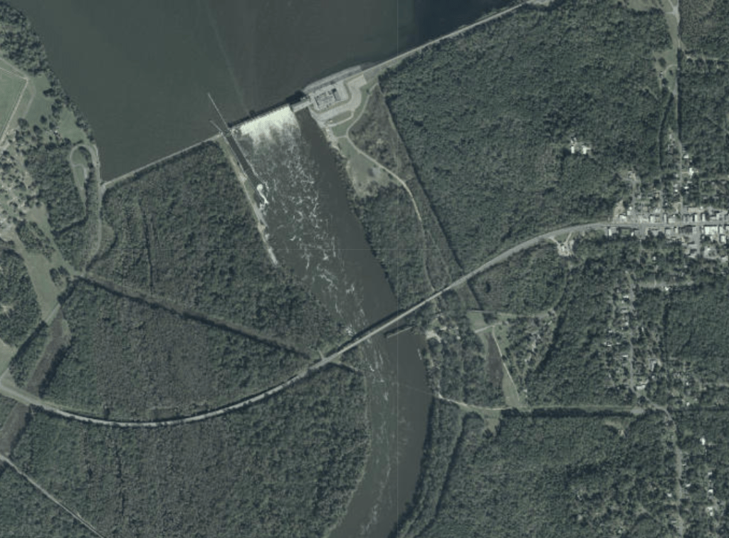
I think a lot about how places like this, where rivers come together or bubble underground, where they cascade over the fall line, or where they break into rapids, have been important to everyone who’s ever lived along their banks. The place where these mighty rivers came together was so important to the United States that it invested millions of dollars, expended the political capital to flood the surrounding country, and devoted itself to maintaining a concrete wall in perpetuity just to try and harness a little bit of that power and convert it into electricity. Think about how important such a place would have been in a world without a GPS to tell you how to get where you’re going. A world where water runs with the literal spirits of the earth and carries life or death in the current. This is why I study environmental history.
I’ve been putting these on Vimeo, but I decided to take the plunge tonight and create a whole branded YouTube thing. So, if you have approximately four minutes, check out my channel, Minute Wild. Thank you so much!
Road trip time. Day and Night 1.
In Florida, a different is always just a short ride away. These magical scenes are less than forty-five minutes away from my house in midtown Tallahassee.


